Wednesday, June 15, 2011

On Sunday Brandon and I rented jet skis and headed out in the Pacific along the CR coast. We were on a guided tour but it was a great time. Definately want to do this again back home.


On Tuesday most of the group took a tour of Manuel Antonio National Park and saw a lot of wildlife. We had a great guide, Johann, who took a lot of time to point things out. Most things were tiny or at a good distance, so we used his scope to get better pictures.

This is most of the group we are with in Costa Rica.


We didn't even get out of the driveway of our house before the guide pointed out Squirrel Monkeys and a Three Toed Sloth. The sloth is in this picutre.


We saw a lot of frogs, lizards and geckos but I have trouble remembering most of their names.


A Fiery-billed Aracari.


Howler Monkey


An Anole.


An Ameiva Lizard.


A close up of a two toed sloth.


A Black Iguana.


A White Nosed Coati.
Posted by Picasa

Saturday, June 11, 2011

Costa Rica Trip, June 2011

Here is a white face monkey that visited our house. We placed bananas on the deck railing and several monkeys came to visit.


We took an awesome zip line tour across the canopy of a rain forest Saturday. A couple friends of my parents, Rick and Kimberly, came too and we met two guys from Chicago, Anthony and Jimmy, who were in our group.


The trip took us across 10 different zip lines over the forest. Here is our group just before the longest section, which was over 1000 ft long.


And here I am going across this section.


Almost all the way across. Pretty amazing.


This was the highest section, over 100 meters to the forest floor.


Rick proposed to Kimberly after one of the sections!


Poison Dart frog.


We went on a waterfall swiming tour...


...and went ATVing, tearing it up along and through a river bed.


Brandon did a good job of getting everyone wet and muddy.


Posted by Picasa

Friday, October 31, 2008

Mt Rogers, Va

10/27/08 Hiking in the Mt Rogers National Recreation Area

Since I was in the Appalachains for a friends wedding and had a few days off afterward, I decided to test a new pack that I bought. I did so by hiking and camping in the Mt Rogers National Recreation Area with Nugget. Mt Rogers is the highest point in Virginia. I knew it was going to be cold and windy with a few snow flurries, but was prepared with plenty of food and gear.

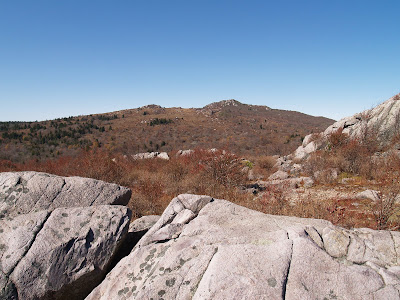
This is the area where I was hiking. Mt Rogers is beyond the distant mountains. It was 30 degrees when we left in the morning, which was about as warm as it got all day.


Nugget had a pack to carry his food and water. A few of the snow flurries are resting on his back. He didn't seem to mind the pack once I put it on him. He did a great job of pulling me up the hills too.


Here is a cool waterfall on Quebec Branch Creek.


This is looking back toward where I started, the low spot in the distant mountains. I first arrived in the Recreation Area by driving 40 min up a 4x4 road to that spot, which was a old cattle staging area but is now a fairly nice camping area.


Nugget is toughing it out. He was pretty cold the night before and shivered most of the night in my tent. He was much better when we were moving. My new pack is on the left. It probably weighed around 50 lbs with all my gear.


I hiked just beyond these mountains, known as Wilburn Ridge, and set up camp just beyond Rhododendron Gap at around 5500 ft. It was pretty early at around 4 pm but I was exhausted after hiking about 8 miles with full pack and it was also cold and windy. I wanted to set up camp and eat before it got dark. I found a fairly flat grassy area near a grove of trees that protected me from the strongest winds.


As you can see from this picture it was pretty clear in the afternoon. But as I got to Rhododendron Gap it was getting pretty cloudy, and by the time I got into the tent for the night, around 6 pm, it began to snow and graupel. Through the entire night winds were gusting over 40 mph at the tree tops with snow and graupel continuing to fall. Nugget shivered all night again and I tried to keep him warm by putting some of my extra clothes on him. I was getting pretty worried about whether I would be able to find the trail to get back to my truck and was contemplating holding up in my tent until the storm passed. I was also worried about Nugget shivering all night.

I finally ventured out of the tent around 9 am and there was about an inch of wind blown snow on the ground. It was still windy, snowing and graupeling, and the visibility was about 100 ft. I found the trail and decided to pack up camp and attempt to make it back to my truck. There was a horse trail that was fairly wide and rocky and easy to find even with snow on the ground. The horse trail was also a shortcut making the trip back to my truck about 3 miles, which took about an hour.

I wish I taken a picture of the snow but had my digital SLR camera in my pack. I really wanted to get off the mountain and didn't feel like digging it out. I need to get a thin digital camera to carry in my pocket to get lots of pictures in these situations.

Sunday, September 28, 2008

9/28/09 - I was able to take a helicopter flight above the fire today. This is the helicopter we took, an Alouette A-Star.


Taking off from the Hood River airport. There are several types of helicopters working the fire and one fixed wing aircraft.

Here we are approaching the Northern slopes of Mt Hood above the fire.

This is Cloud Cap Inn which is a famous building on the mountain that has been there for over a hundred year. The fire burned all around it but the fire fighers were able to save all the buildings.

There are a few smoldering hot spots up on the mountain but for the most part there is no active fire at this time.


Here are some burned areas on the Northeast side of the mountain.


...and on the North side of the mountain.


This is the road up to Cloud Cap Inn. There are huge machines that are taking down dangerous trees, or snags, so it is safe to travel up to the Inn.

This is the Parkdale lava flow between the fire and fire camp. It is a 7,700 year old lava flow from Mt Hood.

9/27/08 - Fire Camp tour. Here is an aerial photo I took of the Incident Command Post (ICP) or Fire Camp at the Hood River County Fairgrounds. It becomes a pretty self sufficient city suppling almost everything one needs.


One of the first things you notice when you get into camp are all the tents. It doesn't seem like there are 500 tents in camp but the food trailer makes meals for 500 people.

Here is the heartbeat of camp, all the section trailers. All the operations and admin take place in these trailers. I work the the closest trailer on the right with the Fire Behavior Analyst and the GIS team.

Here is where the crew briefings take place. I have to give briefings to the crew at 6 am and 5pm. I also give briefings to remote Spike camps via radio at 7 am and to the aviation crew at 7:30 am at the helispot a few miles away. There are also planning meetings where I brief the sections chiefs at Noon and 7 pm.

Here is the dining area. The trailer in the back is where breakfast and dinner is prepared and we eat in the tents.


This building is part of the fairgrounds but it is used for the communications section and medical section for the fire camp.

Here is supply where just about anything from fire gear and clothes to office supplies can be picked up. The trailer to the right is where bag lunches are handed out.

There are even portable showers in a trailer. You can see the potable water truck filling up the huge bladders for the showers. I haven't actually showered in this trailer yet. There are permanent restroom facilities with showers as part of the fairgrounds.